Skip navigation
Home
Browse
Collections
Browse Items by:
Corporate Author
Author
Title Holder/Company
Subject
1:100k mapsheet
1:250k mapsheet
Drillhole
Geological Province
Mine or Prospect
Document Type
Map Scale
Bottom Hole Formation
Survey Name
Stratigraphic Name
Contact Us
Download
Request
Help
Sign on to:
GEMIS
Receive email
updates
Edit Profile
GEMIS
Search
Search:
All Collections
NTGS Products
AGES abstracts and other papers
Digital Information Packages
Geophysical and Remote Sensing Data
HyLogger Data
Maps and Explanatory Notes
Reports, Records, Books
for
Current filters:
Report ID
Document Type
Author
Title
Drillhole
Mine or Prospect
Subject
Title Holder/Company
Abstract
Tenure
Stratigraphy
GIS version
Geological Province
Map250
Map100
Year
Collection
Publisher
Date Added
Equals
Contains
ID
Not Equals
Not Contains
Not ID
Start a new search
Add filters:
Use filters to refine the search results.
Report ID
Document Type
Author
Title
Drillhole
Mine or Prospect
Subject
Title Holder/Company
Abstract
Tenure
Stratigraphy
GIS version
Geological Province
Map250
Map100
Year
Collection
Publisher
Date Added
Equals
Contains
ID
Not Equals
Not Contains
Not ID
Results 1-50 of 407 (Search time: 0.002 seconds).
previous
1
2
3
4
...
9
next
Item hits:
Year
Title
Title Holder/Company
Report id
Preview
Download
2002
Detailed wellsite logs for 99VRNTGSDD1 and 99VRNTGSDD2, Victoria River Basin, Northern Territory
-
NTGS Technical Note 2002-016
1 file
2004
Amadeus Basin seismic interpretation project
-
NTGS Record 2004-011
2 files
1999
Landsat 7 : NT Scene 104/68-104/69- 105/69 mosaic
-
-
2007
1:250 000 geological map series BMR explanatory notes of the Northern Territory: compilation
-
NTGS Special Publication 3
1 file
2000
Amadeus Central : magnetics and radiometrics survey
-
-
2 files
2001
Tanami, Northern Territory : interpreted geology
-
-
1 file
2000
Tanami, Northern Territory : sheet 4858
-
-
1 file
2001
Pargee, Northern Territory : sheet 4758
-
-
1 file
2000
Pargee, Northern Territory : interpreted geology
-
-
1 file
2007
1:100 000 geological map series BMR explanatory notes of the Northern Territory: compilation
-
NTGS Special Publication 4
1 file
2001
Waterloo : magnetics and radiometrics survey
-
-
2 files
2000
West Arnhem : magnetics and radiometrics survey
-
-
2 files
2007
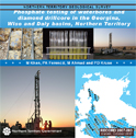
Phosphate testing of waterbores and diamond drillcore in the Georgina, Wiso and Daly basins, Northern Territory
-
NTGS Record 2007-003
1 file
2002
Buchanan : magnetics and radiometrics survey
-
-
4 files
2004
Simpson : magnetics and radiometrics survey
-
-
6 files
2000
Wiso : magnetics and radiometrics survey
-
-
4 files
2001
Eromanga : magnetics and radiometrics survey
-
-
4 files
2006
Tiwi Islands : magnetics and radiometrics survey
-
-
4 files
2002
Georgina : magnetics and radiometrics survey
-
-
4 files
2007
Tanumbirini : magnetics and radiometrics survey
-
-
4 files
2001
Barkly : magnetics and radiometrics survey
-
-
3 files
2008
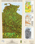
Magnetic depths of the Northern Territory
-
-
1 file
2004
Jervois : magnetics and radiometrics survey
-
-
2 files
2000
Mary River : magnetics and radiometrics survey
-
-
2 files
2000
Bauhinia : magnetics and radiometrics survey
-
-
2 files
2001
Sturt : magnetics and radiometrics survey
-
-
2 files
2000
Landsat 7 : NT Scene 102/78 (26/06/00)
-
-
1 file
2000
Landsat 7 : NT Scene 105/69 (16/08/01)
-
-
1 file
2000
Future work programs
-
-
2000
Landsat 7 : NT Scene 105/75 (20/08/99)
-
-
1 file
2004
The Daly River Mineral Field
-
-
2002
NTGS exploration initiative : 1998-2002
-
NTGS Record 2002-008
1 file
2003
Rare earth element mineralisation in the eastern Arunta Region
-
NTGS Record 2003-004
1 file
2001
Landsat 7 : NT Scene 102/76 (14/07/99)
-
-
1 file
2003
Geological relationships between the Tanami and North Arunta Regions: evidence from 40Ar/39Ar geochronology
-
-
2000
Landsat 7 : NT Scene 100/74 (31/05/00)
-
-
1 file
2000
Structure of the Woodcutters open pit and implications for mineralisation models
-
NTGS Record 2000-011
1 file
2000
Landsat 7 : NT Scene 103/78 (21/06/00)
-
-
1 file
2009
Calibrated radiometrics and threshold image
-
-
2004
Amadeus Basin SEEBASE Project
-
NTGS Record 2004-010
2 files
2000
Landsat 7 : NT Scene 105/70 (21/07/00)
-
-
1 file
2007
OZ SEEBASE : Proterozoic basins
-
-
2009
Geology and mineral potential of the Murphy Inlier region
-
-
2000
Landsat 7 : NT Scene 101/73 (06/05/00)
-
-
1 file
2003
Hydrothermal fluids in the Tanami/north Arunta boundary zone: preliminary results
-
-
2001
Rum Jungle Region and the Pine Creek Orogen: Synthesis and evaluation of existing data
-
-
2006
NT mineral exploration overview 2005
-
-
2001
Landsat 7 : NT Scene 102/72 (29/05/00)
-
-
1 file
2000
Landsat 7 : NT Scene 106/72 (11/08/99)
-
-
1 file
2003
Event chronology in the Arunta Region
-
-
Results 1-50 of 407 (Search time: 0.002 seconds).
previous
1
2
3
4
...
9
next
Discover
Collection
185
AGES abstracts and other papers
2
Digital Information Packages
79
Geophysical and Remote Sensing Data
74
Maps and Explanatory Notes
67
Reports, Records, Books
Document Type
175
AGES Abstract
65
NTGS Record
57
Remote Sensed Data
47
GIS Data
30
250k Geological Map
24
Explanatory Note
16
100k Geological Map
16
Airborne Magnetic and Radiometric...
16
Interpreted Geology Map
9
NTGS Report
.
next >
Geological Province
7
Aileron Province
41
Amadeus Basin
2
Arafura Basin
68
Arunta Region
29
Birrindudu Basin
2
Bonaparte Basin
2
Canning Basin
15
Carpentaria Basin
9
Daly Basin
4
Davenport Province
.
next >
Map 250
8
Alcoota SF5310
8
Alice Springs SF5314
8
Alligator River SD5301
9
Alroy SE5315
6
Auvergne SD5215
.
next >
Map 100
1
Adam 6451
1
Aileron 5552
2
Algamba 6253
1
Alice Springs 5650
2
Alkea 6353
.
next >
Year
25
2008
29
2007
30
2006
42
2005
42
2004
32
2003
44
2002
60
2001
81
2000
4
1999
.
next >