GEMIS HELP
Last update: March 2017
Help Contents:
· Browse
· OBTAINING COPIES OF REPORTS AND DATA
· NOTIFICATION OF ADDITIONS TO COLLECTIONS
· Platform
About GEMIS
Geoscience Exploration and Mining Information System
(GEMIS) is an online database for accessing geoscientific reports and
data kept by the Northern Territory Geological Survey (NTGS). Content is organised
hierarchically within communities, subcommunities and
collections.
GEMIS currently contains the Industry Reports, NTGS Products and Core
Library Communities:
Additional collections will be added as content is prepared.
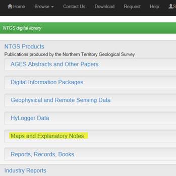
NTGS Products Collections
Information about each of the six product collections is available on the each of the collection home pages.
AGES Abstracts and Other Papers
Digital
Information Packages
Geophysical and
Remote Sensing Data
HyLogger Data
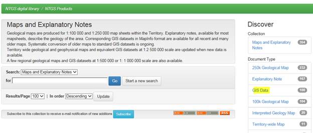
Maps and
Explanatory Notes
Reports, Records
and Books
Industry Report Collections
Minerals Exploration Reports (MEX)
MEX contains open file minerals exploration industry
reports and data submitted to the Northern Territory Government as a statutory
requirement of tenure held under the Mineral
Titles Act.
Energy
Exploration Reports
Petroleum
Wells (Wells)
Petroleum Wells contain Northern Territory onshore open file well
completion reports and associated data submitted to the Northern Territory Government as a statutory
requirement of tenure held under the Petroleum Act.
Petroleum
Geophysical Surveys
Petroleum
Geophysical Surveys contain Northern Territory onshore open file seismic and
other geophysical survey reports and data submitted to the
Northern Territory Government as a statutory requirement of tenure held under
the Petroleum Act.
Core Library
Core Sampling Reports
Core Sampling Reports collection contains reports and data from studies done on drill core and cuttings samples held in the NTGS core libraries. They are submitted to NTGS as a condition of sampling by external government agencies, industry and universities.
The following sections describe how to search using the built in GEMIS functions. The database and document contents are also indexed by web search engines, such as Google, Yahoo and other web based search tools.
Browse
Browse
allows you to scroll through lists of terms in alphabetical order.
There is no option for further filtering therefore browse is best used where
search results are few or if you are unsure of what terms to search for.
The
following table lists the fields available for browsing. Some fields are not
relevant to all collections. For example, the drillhole
list does not include names of drillholes in the
mineral exploration reports.
|
|
Mineral
Exploration Reports |
Petroleum
Wells |
Petroleum
Geophysical Surveys |
NTGS
Products |
Core
Sampling Reports |
|
Corporate Author : The organisation/s responsible for writing the report. |
No |
Yes |
Yes |
Yes |
Yes |
|
Author : The
individual/s responsible for writing the report |
Yes |
No |
No |
Yes |
Yes |
|
Title
Holder/Company : The name of the permit or licence holder/s or operator/s at the time of the
industry report submission |
Yes |
Yes |
Yes |
No |
No |
|
Subject : Use subject to search for reports by
commodities, exploration techniques or methods, stratigraphy, chronology or
report content. Note that indexing may not be comprehensive |
Yes |
Yes |
Yes |
Yes |
Yes |
|
1:100k mapsheet : |
Yes |
Yes |
No |
Yes |
Yes |
|
1:250k mapsheet : |
Yes |
Yes |
Yes |
Yes |
Yes |
|
Drillhole : Standard
drillhole or well name |
No |
Yes |
No |
Yes |
Yes |
|
Geological
Province :
Geological Regions of the Northern Territory are listed alphabetically. Some
of the region names in the list are no longer used, but were current at the
time the reports were written. For information on each region see http://www.geoscience.nt.gov.au/gemis/ntgsjspui/handle/1/81446
|
Yes |
Yes |
Yes |
Yes |
Yes |
|
Mine or Prospect : Mine or
prospect name used by title holder. |
Yes |
No |
No |
Yes |
No |
|
Document Type : Type of
product or well report eg. Map, GIS data, drilling report |
No |
Yes |
Yes |
Yes |
Yes |
|
Map Scale : Scale of
NTGS product maps |
No |
No |
No |
Yes |
No |
|
Bottom Hole Formation : Petroleum
wells bottom hole formation as identified in well completion report. |
No |
Yes |
No |
No |
No |
|
Survey Name : Name used for NTGS gravity, magnetic and radiometric surveys |
No |
No |
Yes |
Yes |
No |
|
Stratigraphic Name :
Stratigraphy identified in Mineral Exploration Report or NTGS product. Note
that indexing may not be comprehensive |
Yes |
No |
No |
Yes |
Yes |
SEARCHING
Start with any term in the quick search box or begin searching by selecting a collection on the home page.
Type any keyword or keywords to search all metadata fields and full text of reports at the same time.
Examples of frequent quick searches are:
by licence number: for example ‘EL456’
by report number: for example ‘CR2013-0001’
by commodity: for example ‘gold’

Use Discover
menus to filter search results.
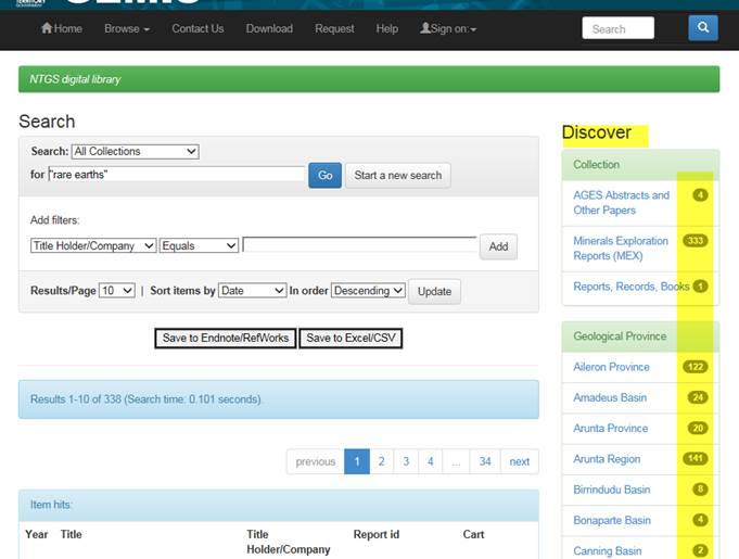
Refine
search results by using additional terms from Discover menus or by adding field filters in the
search box.
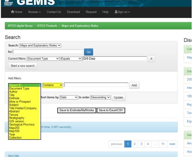
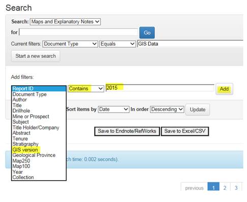
To find
all NTGS maps in GIS format produced in 2015:
1.
Select Collection Maps and Explanatory Notes
2.
Use Discover menu to filter maps with GIS data.
3.
Add filter GIS version, Contains, 2015 by using
drop down menus and clicking Add.
Phrases
More than one word will default to a phrase search (it uses the Boolean
AND between words). For example, if you type ‘Lake
Mackay’ without quotation marks in the search box, it will appear as “Lake
Mackay” and will only find items with the phrase ‘Lake Mackay’.
Stemming
The search engine automatically expands words starting with the search term. For
example ‘drill’ will retrieve records containing the words: drill, drilling, drillers,
drilled etc.
Search Tips and Field Definitions
Report Id: for industry reports include a dash (-) and 4 digits after the year ‘CR2004-0001’,
‘PR2016-0001’
Year: the year the report was written and may not be the same as the year
reference in the report id
Tenure: syntax is title type, eg ‘EL’, ‘ML’ followed by title number without
any spaces, eg ‘EL123’
GIS version: the date the
latest GIS data was published and may not be the same year as the original map
publication,
eg Robinson River 250k map was published in 2002. A
GIS version of the 2002 map boundaries was released on 27/11/2015 2015.
Navigation
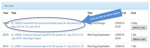
From the
Search Results list, click on the report title for more information about the
report and to view attached files.
Use your
browser back button to return to search results from the document details page.

Obtaining Copies of Reports and Data
The Search Results list indicates how many files in a report are
available for download.
Click on "Add to cart"
link if you know that you want all the available files.
Click on the report title for more information about the report and to
view a list of files available for download.
Individual files can be selected for download.
Files from multiple reports can be added to one download cart.
Contents of the download cart are listed on the download page for
further refinement.
There is an option to download either from the browser window as a
zipped folder or by using a java applet.
The download cart will remain populated between visits if you do not
click “Download Selected”, but will automatically empty after you have downloaded
files.
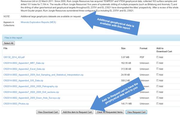
Scanned copies of reports originally submitted in hardcopy are being progressively
added to the downloadable database. If a report or data is not available for
download, you can submit a request for a copy to be sent to you either by
e-mail or on storage media in the mail (dependent on the data volume).
To submit a request, go to the item details page and click![]()
Multiple reports can be added to one request cart.
When you have finished adding reports to the request cart, click ![]()
The request cart will remain populated between visits, but will
automatically empty once you have clicked 'Send'.
Once you have sent your request to NTGS, you will receive an e-mail request
receipt with a tracking number.
NTGS
will not mail copies of reports or data that are available for download unless
there are exceptional circumstances.
Geophysics and Other Large
Datasets
Geophysical
survey datasets and other data types over 1GB are not currently available for
download from GEMIS. Such data can be obtained by submitting an order via the Request
Cart.
Seismic
field data is supplied as a basin package on portable hard drive. Copying and
handling charges apply.
All other
large datasets are supplied free of charge, however you may be required to
supply your own portable hard drive for requests exceeding 34GB.
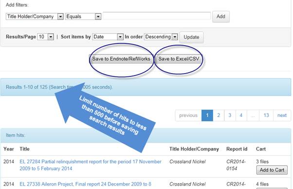
Saving Search Results
The Search
Results screen allows you download the list of reports in either excel/csv or
Endnote/Refworks format.
More than
500 search hits will not save correctly. Refine your search to obtain less than
500 results before saving a list.
Search results obtained by using a Discover
filter may not save correctly. A fix for this bug is in development.
Meanwhile, searches using the quick search and “add filters” function can be
saved.
There are
permanent links (URI) for individual reports which can be cited or e-mailed
allowing for downloading later.
When
citing information in the report NTGS recommends using the following fields:
Author/s, Date, Title, Publisher or Title holder, URI
Notification of additions to collections
From
the collection home pages, you can subscribe for e-mail notification
when additional reports or data become available. New data can be either newly
released open file reports (legislated public release industry reports) or newly
scanned material or newly released/updated NTGS products.
RSS - is an
alternative to email updates if you prefer notification of reports added to
GEMIS via a browser or mobile device RSS reader.

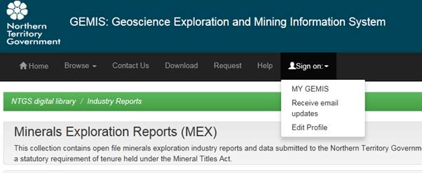
Sign-on in the top menu to:
My GEMIS allows
you to add or cancel your e-mail alerts.
Receive
e-mail updates is an alternative to subscribing from the collection home page.
Edit
profile allows you to manage your contact details and password. Passwords
are case sensitive.
Platform
DSpace
GEMIS is
built on the Dspace open source repository software
package. Further information about Dspace can be
found at http://www.dspace.org/